Day 1: Schwaz-Lamsenjoch
| Distance | Up | Down | Time |
|---|---|---|---|
| 15km | +1450m | -100m | 4h |
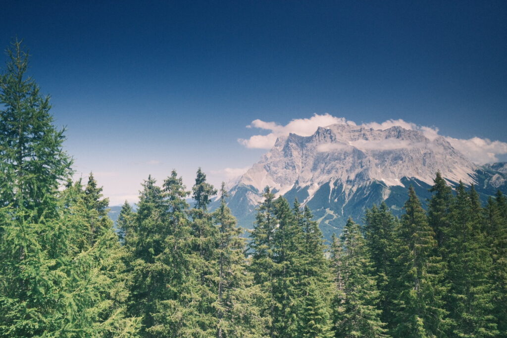
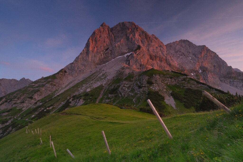
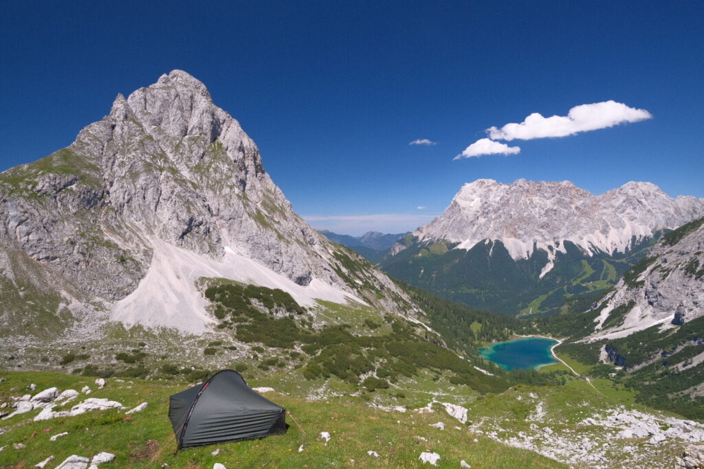
When I leave behind the village of Schwaz around 11 o’clock it must be already around 30 degrees Celsius. Walking with this heat through the streets is strenuous and I cannot await to reach the forest just uphill after 2 kilometres. After a short uphill walk on a forest trail the path follows a forest street into the Stallental valley until reaching the Stallenalm where a fountain invites to refill the water bottle. We can already recognise the towering limestone walls introducing the Karwendel mountain range. The remaining uphill walk to the Lamsenjoch goes through landscapes very similar like seen in the Dolomites. At an altitude of around 1800 metres above sea level the Lamsenjoch mountain hut appears finally on the horizon below the impressive walls of the Lamsenspitze. The Lamsenjoch mountain hut is highly popular and almost all days are already fully booked as is today’s sunday night since some days already. Therefore I continue my walk and search a camping spot on a grassy hill below the north face of the Lamsenspitze out of sight from the Lamsenjoch hut. A beautiful and quiet place to spend the night in the mountains.
Day 2: Lamsenjoch-Falkenhütte
| Distance | Up | Down | Time |
|---|---|---|---|
| 11km | +700m | -800m | 3.15h |
The night was incredibly warm and dry but a thin layer of clouds covers the sky in the morning. The first section of today’s hike leads downhill passing by the tiny Bins Alm and further on until the Eng alpine pasture a little settlement at the upper end of the Hinterisstal. The meadows of the valley floor are dotted with thousands of picturesque sycamore maple trees some of them aging up to 700 years.
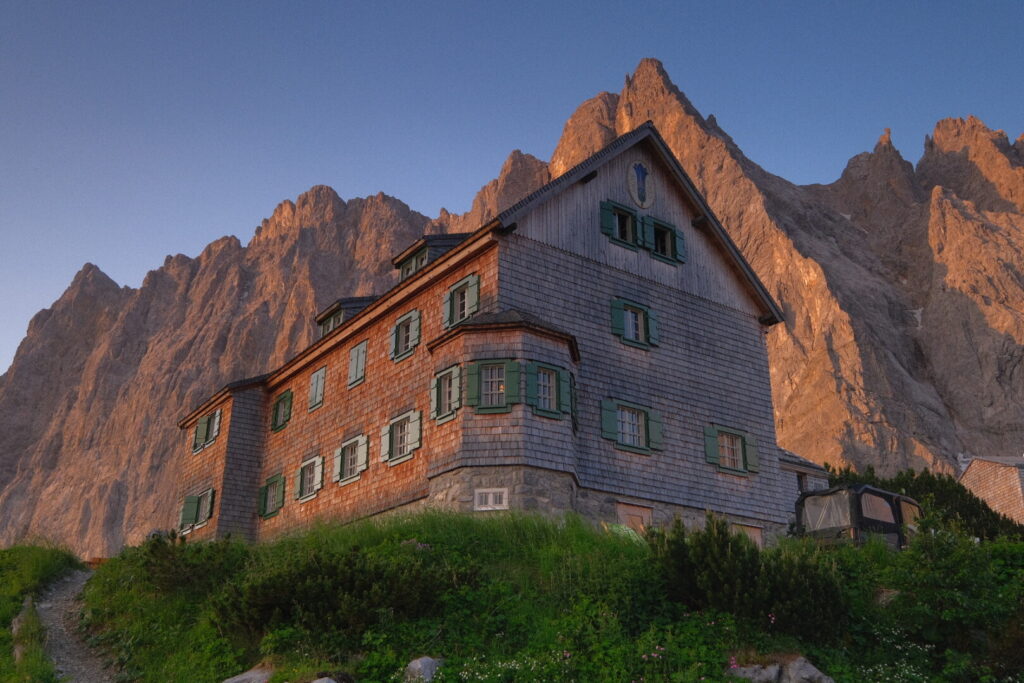
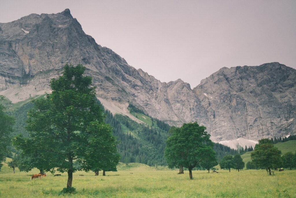 The whole floor is known as Grosser Ahornboden (Great Maple Floor) and once voted the most beautiful place in Tyrol. Being accessible by road this place has found its destination for mass tourism especially during autumn when the maple trees turn orange and red. The route continues now uphill towards the Hohljoch getting closer and closer to the vertical limestone walls of the Karwendel main range and the famous Laliderer north face towering up 900 meters making in one of the tallest all over the alps. The trail follows just below these massive walls to the alpine mountain hut Falkenhütte located underneath the Lalidererspitze with a close-up panoramic view. This hut without doubt is popular as well but arriving there early in the day on a weekday there are still some free places available.
Day 3: Falkenhütte-Scharnitz
| Distance | Up | Down | Time |
|---|---|---|---|
| 26km | +500m | -1300m | 5.5h |
The final day in the Karwendel mountain range has arrived and it is the final day of a 5 day lasting heat period, too. It will be a sunny and hot day with a long walk through the Karwendel valley down to Scharnitz. The Falkenhütte hut is another great place for vegans as they have multiple vegan entries on their menu and the breakfast has also a lot of vegan dips, veggies and oatdrink. A long hike is awaiting me for once I am leaving among the first. Its again a gentle downhill walk through alpine meadow until the small maple floor which is a lot more idyllic and quiet than its big brother. I linger around and relax in the shadow of a tree before the sole ascent of the whole day leading up to the Hochalm saddle and the nearby hut Karwendelhaus, spectacularly situated on the edge of a dramatic cliff overlooking the Karwendeltal valley.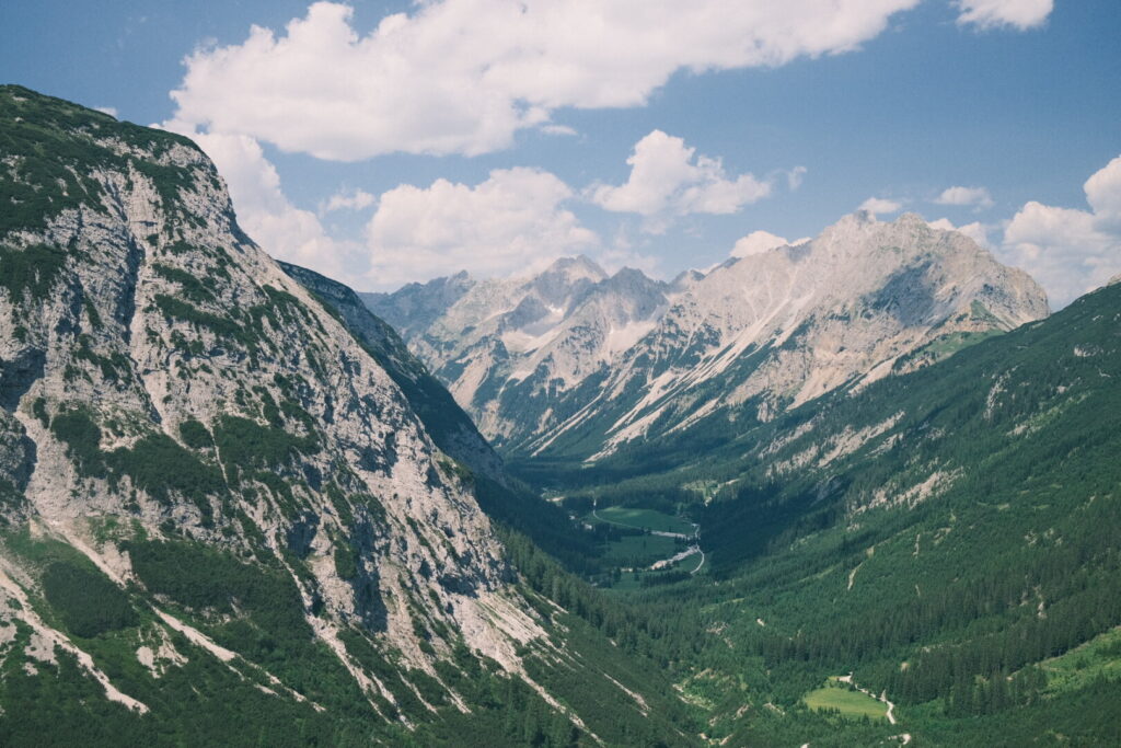 This place is under control of bikers which cycling up here all the way from Scharnitz. The Karwendelhaus has a vegan lentils curry on their menu but the cycle tourist crowds are not inviting to spend much time here during lunch time and its still a long walk of 4 hours lying ahead. The first section climbs down into the Karwendel valley until reaching the valley floor from where a long nature road runs flat through the valley floor always in close distance to the Karwendelbach stream. At some point a waterfall comes down the mountain and I take a bath in a natural pool. What a great refreshing on these hot temperatures. The stream gets now stronger and wilder until it enters a deep gorge through a waterfall just some kilometres away from Scharnitz. After over 25 kilometres hiking I am finally approaching Scharnitz where the Isar river coming down through the Hinterautal valley from the Karwendel mountains. Here the river is still wild and turquoise blue coloured and far away from the big river flowing through Munich and later into the Danube and the black sea. Scharnitz often referred to as the gateway to the Karwendel is surprisingly calm and laid-back. I am getting a room in a house of an older couple. In the evening I visit a place called Alte Mühle for dinner. A cultural place with theater performances, concerts, children playground and a pizzeria.
Day 4: Scharnitz-Leutasch
| Distance | Up | Down | Time |
|---|---|---|---|
| 10km | +550m | -400m | 2.5h |
During the last night a heavy thunderstorm went over Tyrol (and many other areas around the central and eastern alps) marking the end of the heat period and causing a lot of damage. Blizzards went down every couple of seconds and wind gusts strong enough to uproot trees swept over the country. For sure no night to sleep in a tent. The next two days will be characterised by unstable weather, rain, thunderstorms and colder temperatures. I decided therefore to split the oncoming stage and just walk over the high saddle into the Leutasch valley and postpone the climb up into the Wetterstein mountain range to one day later as the weather should calm down tomorrow in the evening. The hike is quiet unspectacular and going mainly through the forest. After 2 hours I reach in the Leutasch valley first in Ahrn but after unsuccessfully searching an accommodation I end up in another settlement called Gasse. In the same house as the Pizzeria Weisses Rössl can be found a rustic equipped hotel and an attached hostel on the ground floor. The whole place seems closed today but somehow I can arrange to spend the night in the dormitory and use the shared kitchen all for myself. 1km away in another place called Weidach there is a super market and I stock up for some proper self made vegan food to prepare in the evening.
Day 5: Leutasch-Meilerhütte
| Distance | Up | Down | Time |
|---|---|---|---|
| 11.5km | +1300m | -50m | 3.5h |
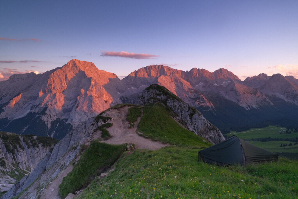
Today is another lazy morning. I get up late and spoil myself with a tasty breakfast like back at home while watching the rain falling down outside. Around 1PM the rain has stopped and a dry window is coming in. Reaching the Meilerhütte seems realistic in under 4 hours so I should still arrive in the late afternoon before the thunderstorm. The first couple of kilometres are quiet flat walking in the Leutasch valley followed by a gentle uphill ascent through the forest into the Berglein valley. By leaving the forest the trail gets more rocky and steeper with a more alpine character. Due to the fog the visibility is pretty limited. After climbing up over 1000 metres of elevation gain a last scramble up through loose rocks separates me from the mountain hut which was build directly on top of the ridge surrounded by peaks. A dramatic location on the borderline between Tyrol and Bavaria. Later in the evening the sky clears up and opens a truly beautiful view into the Wettstein mountains and two days of perfect weather lay ahead to explore these mountains.
Day 6: Meilerhütte-Gatterl
| Distance | Up | Down | Time |
|---|---|---|---|
| 22km | +1250m | -1500m | 7h |
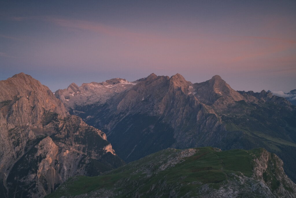
The Meilerhütte is a small, authentic and basic mountain hut without all the bells and whistles found in other more touristic places and the location is unbeatable. Three climbers who cross the three peaks of the Partenkirchner Dreitorspitze give me some interesting insights about the Wetterstein & Mieminger chains and possible bivouac places. A day with stable weather lays ahead and I hope to reach as far as possible. Crossing down from the ridge into Bavaria opens up a wide view to the Wetterstein mountain group and Germany’s highest peak Zugspitze which seems to make people from this country go crazy.
 The trail leads down to the Schachen viewpoint and from there to the Reintal valley on a steep and wet trail which requires quite some care especially after the rain of the previous days. After climbing down over 1300 metres I arrive finally at the Reintal valley where many tourists from Garmisch Partenkirchen make their way to reach the Zugspitze. Its a long but rather flat uphill walk through the Reintal valley towards the Reintalanger hut. A place of an incredibly chaotic organisation and poor service quality as there was nobody taking care to guests during one hour and other stories I was told by people who stayed their overnight. Avoid this place by any means. After waiting one hour for a vegan cake and disrespectful treatment I literally run away from the place to hike up 700 metres to the Knorr mountain hut a popular base to walk up to the Zugspitze peak. Its a strenuous climb up there under the burning sun. The Knorr mountain hut is a overpriced place which attracts the same kind of people than the hut before. Pretty soon I leave the scenery behind and continue my way to the Gatterl and the border crossing into Tyrol. The Langtal route and the Zugspitze were a quiet horrible experience which should be avoided on weekend days. The way to the Gatterl a animal fence style border post is a gateway into a dramatic mountain scenery with views to the Mieminger mountain range and wild green valleys inhabited by big chamois herds. On a grassy viewpoint I pitch my tent for the night and enjoy the last sunlight and the silence above the valley
Day 7: Gatterl-Drachenkopf
| Distance | Up | Down | Time |
|---|---|---|---|
| 11km | +600m | -650m | 3.15h |
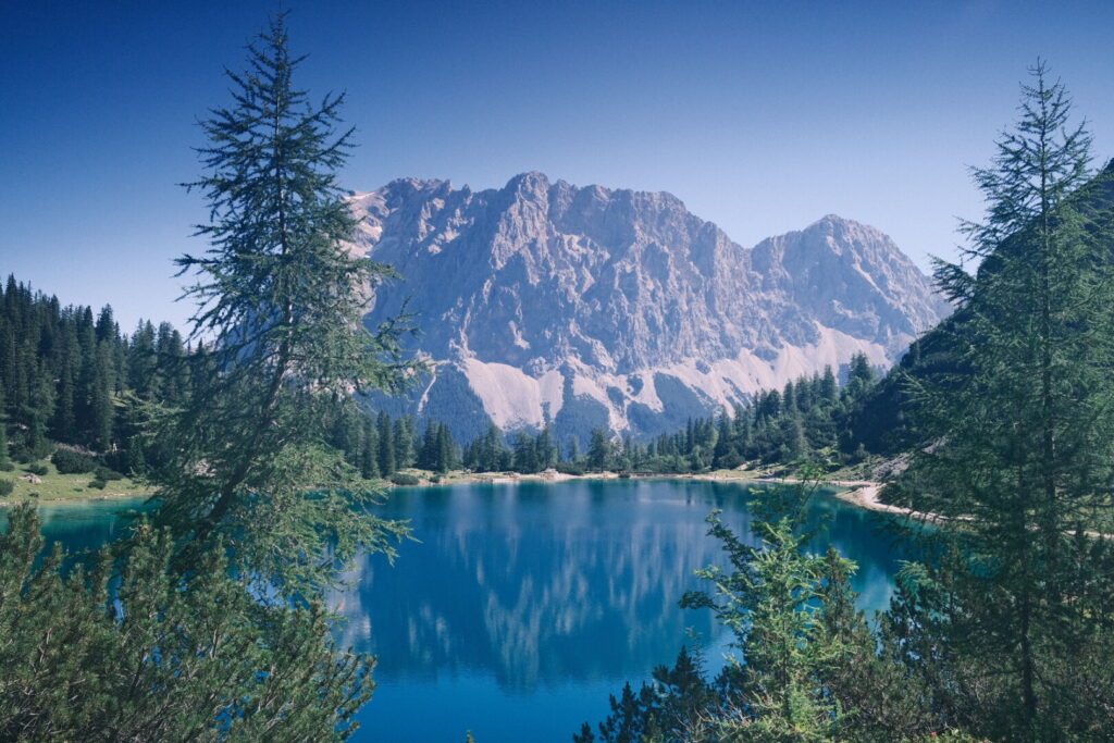
Not too long after the sun rises the first walkers are already on their way towards the Zugspitze. While the trail is quite extinct during the evening there is much action going on in the early hours and especially on a sunny weekend day like today. I take the other turn around and walk below the steep walls of the Wetterwand ridge down into the Gaistal valley separating the Wetterstein and Mieminger ranges. Short past the Hochfelder alpine pasture the trail crosses the Gaisbach stream and starts to ascend gently on a forest trail until reaching the Seeben alpine pasture which is located below the nearby Seeben lake a pristine coloured mountain lake with splendid views to the Wetterstein mountain range and the Zugspitze peak.
 Another 250m higher lies the Drachensee lake and just above the highly popular alpine hut Coburger Hütte which is normally fully booked months in advance and it is quite a hustle there on this Saturday with perfect mountain weather. It’s not only the lakes and the views to the Wetterstein group and the Zugspitze but also the nearby peaks like Tajakopf, Drachenkopf and Sonnenspitze which attract the mountaineering and hiking crowds to this corner. No doubts the fame is deserved but for my personal preferences there is too much of the see and be seen crowd up here running around. So better come here during the week and not in high season. After observing the scenery of Instatourists tasting mountain air for quite a while my personal journey moves on away from the Coburger Hütte up along the trail towards the Drachenkopf mountain. Soon the hiking trail gets less crowded even tough the Drachenkopf summit is a popular hiking summit. I search a spot around 250 metres below the peak with a wonderful view to the Sonnenspitze mountain, the Seeben lake from above and the Wetterstein mountain range.
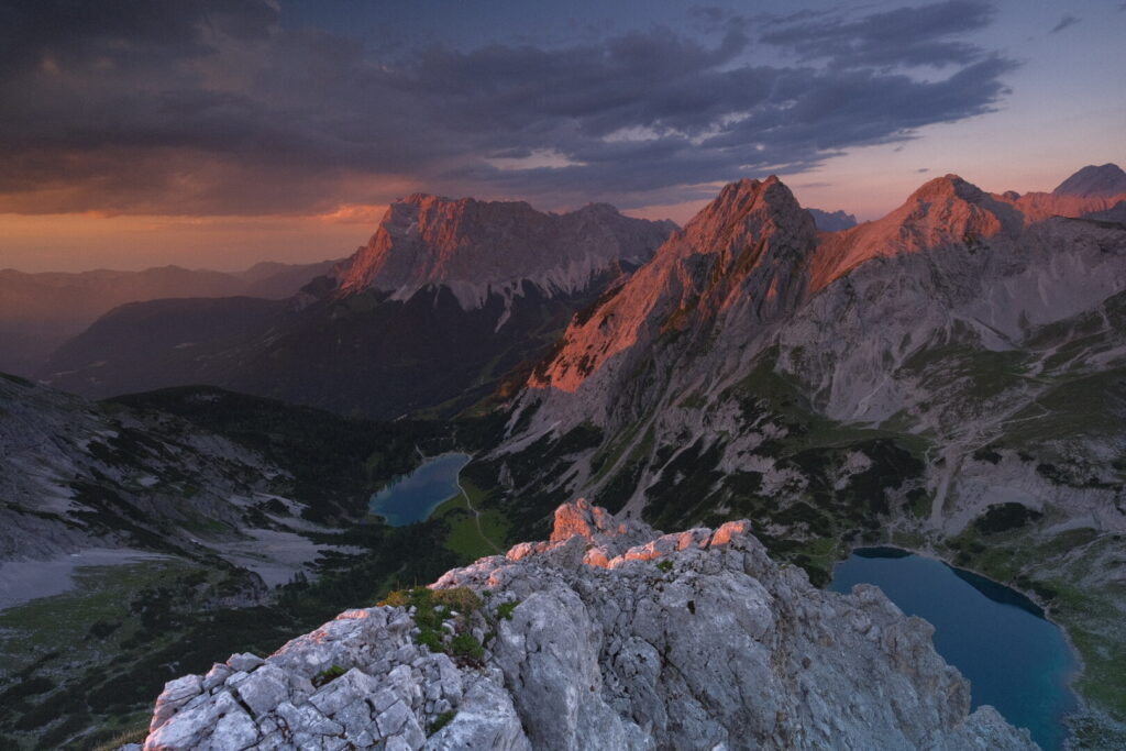
 I spend the afternoon lying around enjoying the warmth of the sun and the mountain scenery. In the early evening I climb up to the Drachenspitze summit to spend the sunset up there. The rocks of these mountains are loose as hell so only go up here with a helmet and with dry conditions. The view from up here at the summit is indeed incredible with all the mountains around and the Seebensee and Drachensee lakes far below. Compared to the ease to get up if you are already at the lakes it’s just a world class view and every Via Alpina hiker should make the small extra effort getting up here if the weather is fine and the equipment is ready. As always special care is required descending down at dawn.
Day 8: Drachenkopf-Wolfratshauserhütte
| Distance | Up | Down | Time |
|---|---|---|---|
| 12.5km | +850m | -1150m | 4h |
Everything is covered by fog when I stretch my head out of the tent early in the morning. After some cereals for breakfast I am getting ready to continue the walk and leave the Wetterstein mountain group behind. Luckily I checked yesterday a shortcut to get back to the official trail to the Biberwierer Scharte a gap between the Sonnenspitze and the Schartenkopf allowing to descend down to the valley which lies 1000 metres below. With this dense fog it would be impossible to find the right direction. Short before arriving at the Biberwierer Scharte I meet a couple in shorts and sneakers on their way into the climbing route up to the Sonnenspitze. Probably they followed the wrong Komoot track. The first section after the Biberwierer Scharte down into the valley is indeed prone to get lost with the limited view due to the fog and gps assistance is really helpful under such conditions. Down at Biberwier named after the Beavers once living in this area we are also leaving behind the Wetterstein and Mieminger ranges and enter the Lechtal Alps which we however only will step into briefly in its northern part in order to reach the Lech valley our gateway into the Allgäu Alps. For today a unexpectedly steep trail leads up through the forest from Biberwier to the Grubig Alm and the close by located Wolfratshauser alpine hut. Getting closer there the sky is clearing up offering one last view back to the Wetterstein mountain range and Germany’s highest peak Zugspitze.