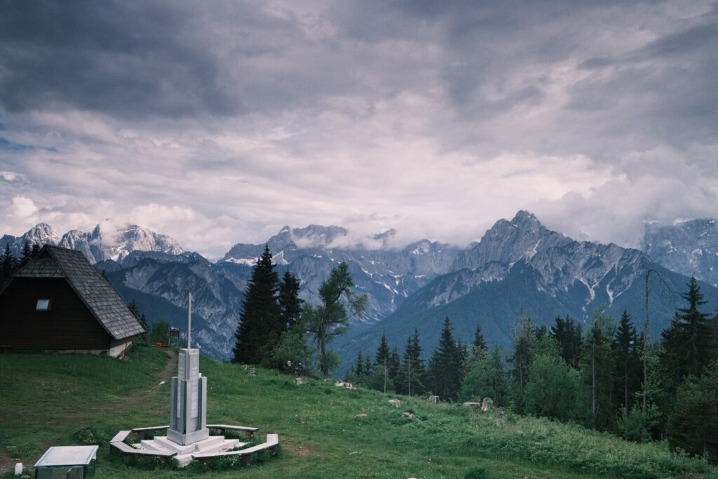
Day 1: Bohinjska Bistrica-Ukanc
| Distance | Up | Down | Time |
|---|---|---|---|
| 16km | +350m | -200m | 3.30h |
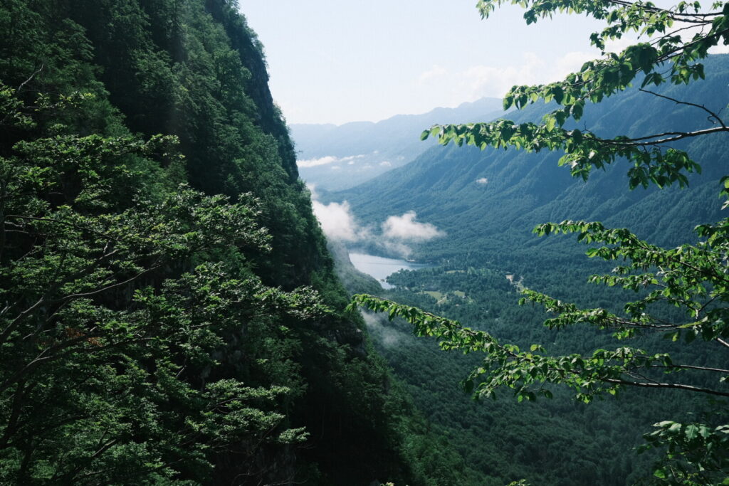
After 24 hours non-stop raining the radar announces a dry window of around 3 hours at 9 o’clock in the morning. It’s a flat walk from Bohinjska Bistrica through the Bohinj valley to Slovenia’s biggest lake. After around 2 hours I arrive at the eastern shore of lake Bohinj at Ribcev Laz where many tourists stroll around. From here a nice path runs on the northern side of the lake to Ukanc a small settlement on the western end of the lake. It seems a quite popular stroll as there are tourists at every corner even with the bad weather. Arriving at the western end of the lake the rain is back and another 3km walk is ahead to the base of the Savica waterfall where I planned to spend the night in a alpine hut. Arriving there after a short but wet uphill walk I am shocked to realise that the hut is closed. Therefore I head back down to the lake to a nice camping on the shore of the lake where I pitch my tent in a wooden area just next to lake Bohinj.
Day 2: Ukanc-Prehodavci
| Distance | Up | Down | Time |
|---|---|---|---|
| 17km | +1600m | -50m | 6.30h |
Early in the morning and without proper breakfast I leave lake Bohinj behind my back and walk smoothly uphill the Savica valley. The Bohinj mountains are still covered in fogs. After 3km the path divides and starts to climb steeply and with countless serpentines into the almost vertical Komarca wall. While gaining height in a exhausting ascent the fog disappears and lake Bohinj is already far away and hardly visible.
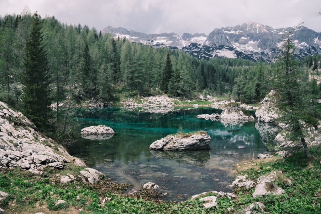
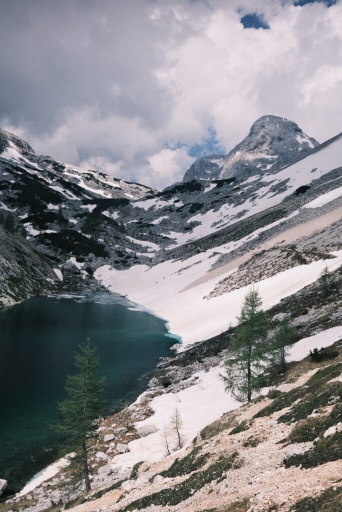
 After a long and demanding climb the trail flattens and descends to the Crno Jezero the first of seven lakes of the seven lakes valley which starts here at an altitude of around 1300m above sea level. The path runs now slighly uphill through beautiful woodlands with a lot of Karst rocks. After another long walk through savage forest the second lake gets into view. We are now already at the tree line and many larches grow at the shore of the Dvojno Jezero a double lake of incredible colors and backed by the Spicje mountain.
 The weather is pretty stable but I need to proceed as a heavy thunderstorm will most probably arrive in the later afternoon. The trail continues above the tree line through beautiful scenery and at around 1800m above sea level snow field start to interrupt the walking trail. At 1850m the third and biggest lake appears surrounded by larch trees and right below the Spicje mountain.
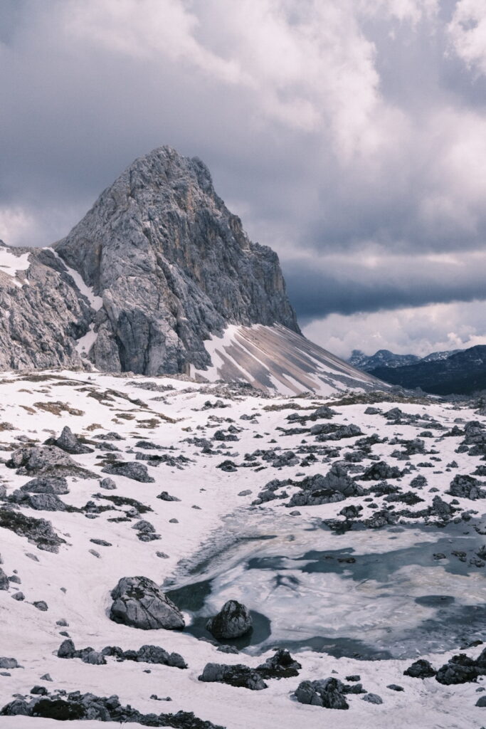
 The following walk goes through a landscape with a large amount of snow and getting ahead requires a lot if energy and some experience navigating in higher mountains. But the scenery is absolutely worth the extra efforts. The remaining lakes are all frozen and perched into snowy mountain landscapes.
 After a long and exhausting walking day through extremely beautiful landscapes I am glad to arrive at the Prehodavci hut where the modern looking winter room provides shelter on an altitude over 2000m above sea level and with great views over the mountains of the Triglav National Park.
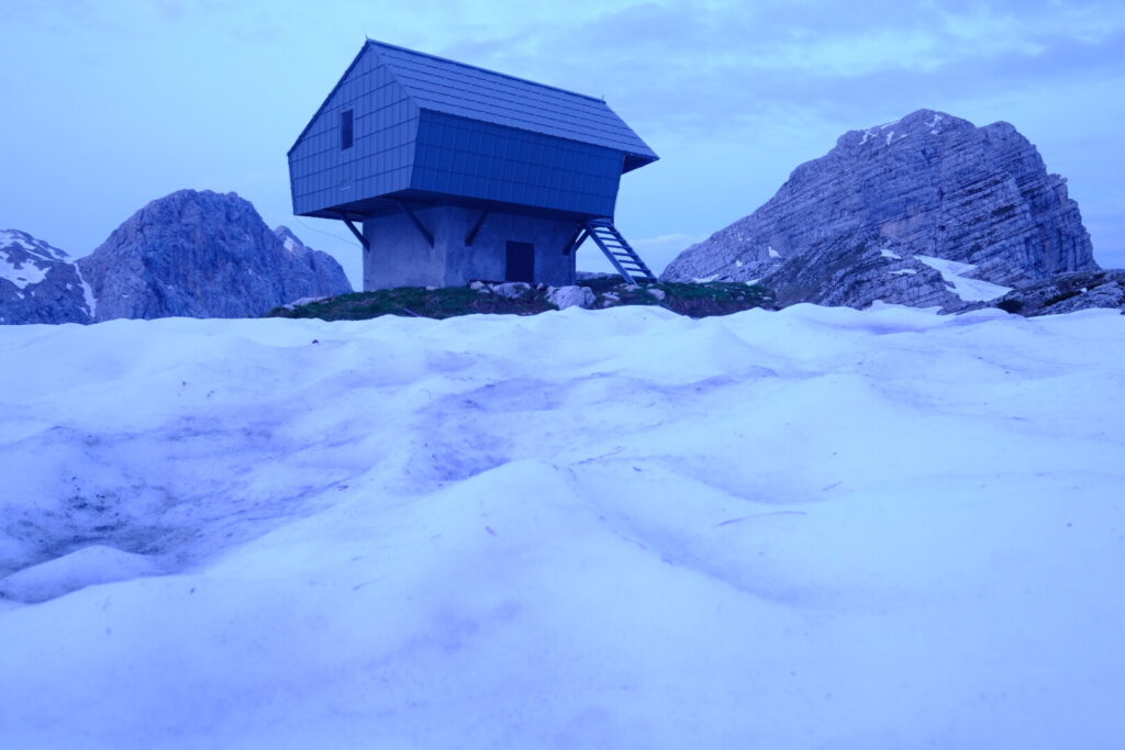 I am lucky to arrive in time as a heavy hailstorm passes over the Triglav mountains short after my arrival. The Triglav Seven Lakes valley and hike are of true beauty and should not be missed on any visit to the area but only be undertaken with stable weather conditions.
Day 3: Prehodavci-Trenta
| Distance | Up | Down | Time |
|---|---|---|---|
| 10km | +0m | -1350m | 3.15h |
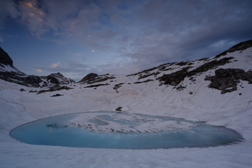
My first night over 2000m on the Via Alpina and its a cold one. Its 4AM and still dark when I leave the Prehodavci winter room. The moon shines bright on my way down through the snow towards a frozen mountain lake which had caught my attention. Its almost perfectly round shaped and a blue color shines under a thin layer of ice surrounded by a snowy landscape and the peaks in the distance.
 On my way back to the mountain hut I hear the familiar sound of pouring water out of a rock and I refill my water bottle with the blue gold. For the workers at the mountain hut the day has already started and all kind of materials and more people are arriving through the air. Meanwhile the sunlight starts to dance on the mountain peaks in all visible directions. It hurts to leave that place and walk down into the Trenta valley from where the famous Soca river flows towards the Italian coast. Its a serpentine path going down through steep terrain crossing various snow fields and lined with many larch trees. One hour later the trail enters a nameless valley which leads through forests into the Trenta valley surrounding the Zadnjiski Ozebnik mountain and walking along the Trebiscnica river. After three hours and 1400m downhill walking I am happy to finally have arrived the valley and entering again hotter climates. Its still middle of tge day and I could climb already today to the Vrsic Pass put I prefer to spend some time in the valley on the banks of the Soca River.
Day 4: Trenta-Vršič Pass
| Distance | Up | Down | Time |
|---|---|---|---|
| 9.5km | +1000m | -50m | 3h |
It takes hours until the first sun rays reach the bottom of the valley where I spent the night on a tiny camping just next to the Soca river. Wherever you look herds of tourists flood into the valley from all directions to enjoy time at this smaragd green river which is considered to be one of the most beautiful in Europe. It seems in this valley German is the second official language and almost all foreign visitors arrive from Germany. There is a well known trail from Trenta along the river uphill towards the source so its no surprise I cross more people walking than before since I am on the Via Alpina and its indeed a beautiful walk. Short before the source the walking path splits and continues steeper up the Trenta valley for two hours before arriving at the Vršič Pass which is the highest Slovenian Pass accessible for cars. Its equally popular among moto cyclists as people traveling with camper vans so its never quiet up here. From the pass several mountains can be accessed through walking trails and climbing routes and the views are spectacular. I decide to spend the night in the mountain hut Ticarjev dom na Vrsicu and explore the surrounding area on the pass in the afternoon and climb to the viewpoint “Slemenova Špica” for sunset just 3km away and some 100 meters above the pass. A grassy plateau with many trees and an incredible full angle view of the north face of Mount Prisojnik with its high walls towering just in front of you. From a small summit the views extend into all directions and offer a splendid roundup panorama where I can enjoy a beautiful sunset just for myself. Another unbelievable moment in the Triglav National Park.
Day 5: Vršič Pass-Gozd Martuljek
| Distance | Up | Down | Time |
|---|---|---|---|
| 17km | +150m | -950m | 4.15h |
Day 6: Gozd Martuljek-Thörl Maglern
| Distance | Up | Down | Time |
|---|---|---|---|
| 26km | +950m | -1050m | 6.45h |
Clouds are hanging low this morning over the valley and the peaks of the Martuljek group and the pyramid shaped Spik mountain are hidden. Today I will rejoin the official Via Alpina route and enter Kärnten in Austria leaving behind the Julian Alps. The initial part leads trough the upper Sava valley upstream along the Sava Dolinka river perched between the Julian Alps to the south and the Karawanks to the north. Leaving Gozd Martuljek behind the touristic hotspot Kranjska Gora is reached after a couple of kilometers and soon the small village of Podkoren. Its here where the official Via Alpina route enters from the Tamar valley and climbs up to the Wurzenpass and the border with Austria. Walking by the border control the police reminds me its illegal to bypass without presenting papers. Short moments earlier it had started to rain and I continued the uphill walk towards the Dreiländereck always along the italian-austrian border which has been the borderline on many battles and wars. The rain gets more intense but finally stops when I arrive at the Dreiländereck peak and a wide view to all directions opens after the sky clears up.
Its still a long way down through dense forests until Thör Maglern a sleepy border town in Kärnten and I spend the night in the only bed & breakfast in town just some 100 meters away from Italy. After 26km walking I need some recovery time to be ready the “Karnischer Höhenweg” tomorrow which will run westbound along the carnic alps on the borderline between Austria and Italy.